ENTSO-E Transmission System Map
Transmission – Europe
This map is a comprehensive illustration of the transmission system network operated by members of the European Network of Transmission System Operators. In general the map shows all transmission lines designed for 220kV voltage and higher and generation stations with net generation capacity of more than 100MW.
Transmission Network Capacity Map
Distribution – Midlands, South-West England, South Wales
Map provides an indication of the networks capability to connect large-scale developments to major substations. The colour gradings are intended to guide the user to areas of the network where a connection is more likely to be achieved without significant reinforcement.
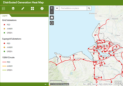
Distributed Generation Heat Maps
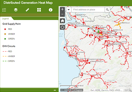
Distribution – South and Central Scotland
Map to help check if existing network is capacble of providing power needed to operate as well as closest grid supply point constraint. Provides indication of potential opportunities to connect Distributed Generation to 11 and 33kV network in SP Distribution licence area.
Planned Projects Mapping Tool
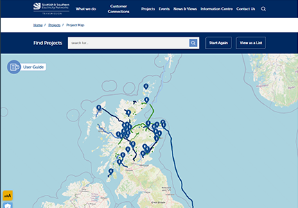
Transmission – North Scotland
Map of planned transmission projects with details of type, location, status and rating.
Contains information on different transmission projects in North Scotland with visuals of progress and size of project, enables easy identification of suitable connections to certain transmission lines within the area.
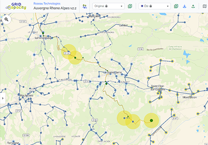
Grid Capacity
Distribution – France
Grid Capacity brings together all open data relating to the public electricity distribution network for most of mainland France, in a single, simple and intuitive web interface.

Network Capacity Heatmap Tool
Distribution – North West England
Contains capacity information on all primary substations and bulk supply points, provides interface that enables easy identification of network constraints in vicinity of site. Will be used for initial discussion between operator and customer.
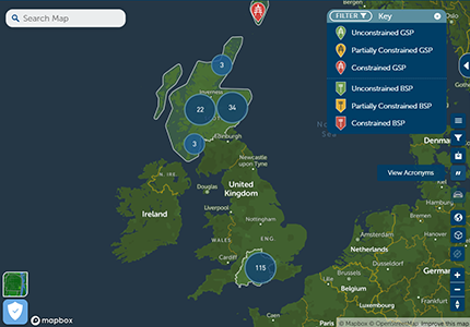
Generation Availability Network Maps
Transmission and Distribution – North Scotland, South England
Map of grid supply points, substations for generation availability and network capacity.
Map shows the different GSPs and BSPs in South-West England and Northern Scotland, shows constrained and unconstrained points with details of each connection point.
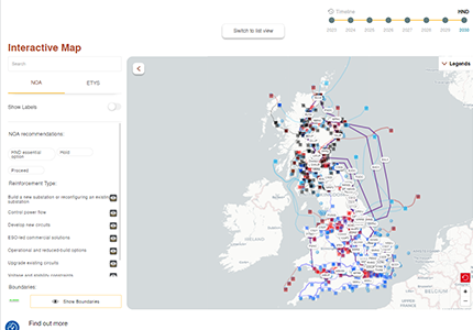
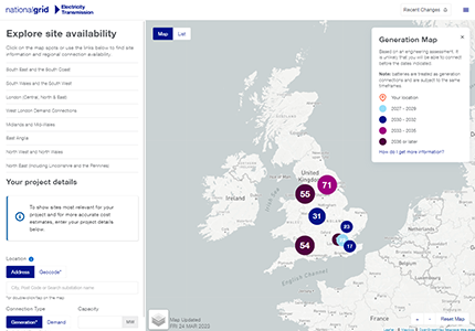
Interactive Connections Map
Transmission – Great Britain
Illustrative map of electricity transmission system, and highlights need to transmit volumes of energy.
Shows future planned projects with specific locations as well as future transmission requirements and capability of National Electricity Transmission system over next 10 years, provides recommendations for which reinforcement projects should receive investment.
Connection Request and Check Tools
Distribution – Great Britain
Digitalise and automate evaluation process for new connection applications. Automated online portal for indicative feedback on potential connection point directly from the grid operator’s website, customisable customer self-service for grid operator, automated calculation of probable grid connect point for new asset.
Manweb Heat Maps
Transmission – North Wales
Map to help check if existing network is capacble of providing power needed to operate as well as closest grid supply point constraint.
Provides indication of potential opportunities to connect Distributed Generation to 11, 33, 132 or 400kVA network in SP Manweb plc licence area.
Distribution Mapping Tool
Distribution – South-East England
Map of substations and distribution system.
Map shows the 132 kV substations, overhead lines, towers and customer connections.
ConnectNow Research Assistant
Transmission – England and Wales
Map with potential demand connections, where location is chosen and the tool generates estimated distance from substation, as well as generation rate.
Designed to provide connection information and investigate options, see connection timeframes, estimate cost profiles, enquire directly to National Grid Elec Transmission for connection. Helps to understand potential connection options, submit enquiries ahead of applying for connection. Gives different charges and options. Not only limited to the area that they are the energy network provider for.
Analyse. Visualise. Decide.
Contact us for a demo of our applications or for more details how we can help with your clean energy or decarbonisation projects.